MULTI-SENSOR, AI-DRIVEN ANALYSIS FOR MODERN MINING
multi-sensor scanning, AI-powered interpretation, and hybrid communication systems
Our portable platform brings together multi-sensor scanning, AI-powered interpretation, and hybrid communication systems to deliver clear, decision-ready insights directly at the point of exploration. Instead of waiting days or weeks for lab results, teams can understand mineral signatures, structural details, and environmental conditions in real time.
ABOUT
GeoSynap Tech
GeoSynap Tech Inc. develops advanced geological solutions designed for the realities of today’s mining and exploration operations.
Across Canada’s mining sector, field teams face slow data turnaround, fragmented workflows, and inconsistent access to reliable analytical tools—especially in remote regions. These delays increase operational uncertainty and slow down resource evaluation. GeoSynap Tech was created to provide a smarter, faster way to collect and understand geological information.
GeoSynap Tech
ADVANTAGE
GeoSynap Tech combines advanced sensors, on-device processing, and flexible connectivity into a single rugged system built for the field.
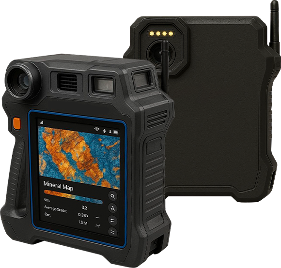
Integrated Multi-Sensor Platform
The device unifies VNIR/SWIR hyperspectral imaging, portable XRF, Raman spectroscopy, LiDAR, GNSS RTK, RGB imaging, and environmental sensors—replacing the need to carry multiple independent tools.
Integrated Multi-Sensor Platform
The device unifies VNIR/SWIR hyperspectral imaging, portable XRF, Raman spectroscopy, LiDAR, GNSS RTK, RGB imaging, and environmental sensors—replacing the need to carry multiple independent tools.
Our purpose is to support exploration companies with technology that improves accuracy, reduces risk, and accelerates project timelines.
Key highlights include
Integrated Multi-Sensor Platform
The device unifies VNIR/SWIR hyperspectral imaging, portable XRF, Raman spectroscopy, LiDAR, GNSS RTK, RGB imaging, and environmental sensors—replacing the need to carry multiple independent tools.
Reliable Connectivity in Remote Locations
With support for Wi-Fi, 4G/5G, LEO satellite, and mesh networking, the system maintains communication and data transfer even where traditional networks fail.
On-Site AI Processing
Powered by the NVIDIA Jetson Orin NX module, the platform performs mineral identification, 3D mapping, and multi-sensor fusion on the spot, enabling immediate interpretation without lab delays.
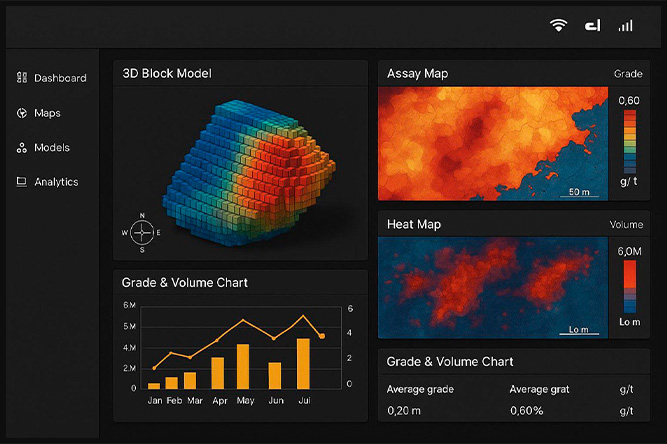
Cloud-Enabled Geological Workflows
Data collected in the field syncs to the GeoSynap Tech Cloud for further processing, updates to 3D block models, and integration with mine planning systems, including SCADA compatibility through OPC UA and MQTT.
GeoSynap Tech delivers clarity, speed, and reliability, helping geologists and engineers work with confidence, no matter the terrain.
PRICING
GeoSynap Tech’s platform is designed for mining operators, exploration firms, and geological agencies, with pricing structured around equipment configuration and operational requirements.
The multi-sensor unit is offered starting at CAD $85,000, inclusive of the core hyperspectral, XRF, Raman, LiDAR, GNSS RTK, and environmental sensing capabilities. Modular upgrades, such as extended-range LiDAR or advanced hyperspectral configurations, are available based on client needs.
As the platform evolves, additional services such as cloud analytics subscriptions and enhanced data-processing packages will be available.
For detailed pricing aligned to your project, please contact us at info@geosynaptech.com.
Jone manages corporate finance, planning, and financial governance. His experience with large-scale budgeting, ERP systems, and investor relations establishes a strong fiscal foundation for scaling the company’s operations.
Dr. Mohammad Naveed Ahmed
Chief Commercial Officer (CCO)
Dr. Naveed oversees business development, commercial strategy, and client partnerships. His background in international sourcing, brand strategy, and technical marketing ensures GeoSynap Tech’s value is clearly positioned within the mining and exploration sectors.
Mohsen Fadhl Ahmed Taleb
Chief Executive Officer (CEO)
Mohsen leads GeoSynap Tech’s strategic direction and operational vision. With over two decades in industrial operations, technology development, and multinational project environments—including involvement in advanced material recovery technologies—he guides the company’s growth across Canada’s mining innovation landscape.
M. Mahmudul Kabir
Chief Operating Officer (COO)
Mahmudul directs production, supply chain, assembly, and operational processes. His background in managing significant budgets and operational teams ensures efficient movement from prototyping to commercial deployment.
Riad Hossain
Vice President of Corporate Strategy & Partnerships
Riad leads strategic planning, partnership development, and regulatory alignment. His expertise in market analysis and corporate strategy supports long-term positioning in Canada’s advanced mining technology market.